SPACEFLIGHT Earth observation satellites
Saving the planet from space
Ahead of the RAeS Conference, Towards a Space Enabled Net Zero Earth later this month, MICHAEL JAEGER, partner and patent attorney from European intellectual property firm, Withers & Rogers, looks at the advances in Earth observation satellite technology.
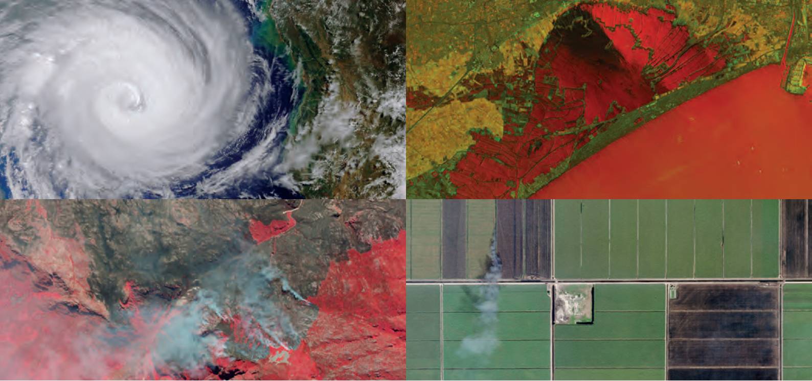 Clockwise from top left: Cyclone west of Madagascar, flooding in Valencia, Spain; sugar cane burning in Florida, US; fire in Western Cape, South Africa. Planet
Earth observation data is currently used to forecast the weather, track biodiversity and wildlife trends and measure land-use changes, such as the rate of deforestation. However, there is potential to use it even more widely in the future to improve sustainability and reduce our environmental impact.
Earth observation involves the collection and analysis of vast quantities of information from instruments monitoring the planet, such as components of satellites and high-altitude balloons. Using these instruments, vast areas of the planet can be assessed, including remote locations that would be otherwise difficult and expensive to monitor continuously.
Generally, Earth observation data consists of a form of digital imagery. ‘Passive’ imagery systems detect electromagnetic radiation, such as thermal infrared, which is emitted or reflected by the Earth’s surface and atmosphere. This information can be used to determine the temperature of the ocean or urban environments, for example. ‘Active’ imaging systems emit electromagnetic radiation and then detect the resulting reflections from the Earth, interacting with elements, such as topography and glacier movements.
As well as tracking weather and land changes, Earth observation can be used to monitor natural disasters, manage natural resources and address emerging diseases. For example, by assessing the release of carbon dioxide, sulfur dioxide, hydrogen sulfide and hydrogen halides from a volcano, seismic activity can be predicted, and warnings issued ahead of an eruption.
Earth observation also holds the potential for reducing humanity’s impact on the environment. By consolidating data surrounding weather, natural disasters and temperature, the effects of climate change can be recorded and mitigation measures suggested. The efficacy of any measures that have been introduced can also then be tracked.
A core area where Earth observation data could be used to improve processes is agriculture. According to the Intergovernmental Panel on Climate Change (IPCC), an estimated 23% of total anthropogenic greenhouse gas emissions come from agriculture, forestry and other land use (AFOLU), with practices remaining essentially the same for over a century. Information from satellites could help to change this, making sustainable farming processes more efficient and less costly as much of the monitoring carried out is currently done manually. Whether the data is used to track soil carbon or forecast yield, Earth observation could be a vital part of making agriculture more eco-friendly.
Due to the considerable potential for Earth observation, it is a field packed with innovation. For example, ICEYE has developed a synthetic-aperture radar (SAR) satellite, which is capable of imaging locations at night, as well as through clouds, fog and smoke. It is also able to acquire coherent ground track repeat (GTR) images of the same location every 24 hours, providing precise and frequent data, no matter the weather conditions. The company owns a number of patent rights (including GB2578793A, GB2578926B and EP3673287A1) relating to this innovation, potentially securing 20 years of exclusivity in the crowded satellite market space.
‘DarkCarb’ is a mission under development by Surrey Satellite Technology Ltd. (SSTL), alongside Leonardo and Satellite Vu, which will enable thermal imaging at an incredibly high-resolution ground sampling distance of around 3.5m GSD. As a result, climate-related monitoring, including heat loss from buildings, could be carried out on a huge scale. Not only will this monitor carbon footprint declarations in the industry but it can also identify homes that would benefit from improved insulation, helping the general public to cut costs and improve wellbeing.
Another environment-focused project is ‘CubeMAP’, a European Space Agency (ESA) mission designed to measure aspects of atmospheric chemistry. Each of the project’s three ‘CubeSats’, which are small enough to fit into a shoebox, carry a thermal infrared spectrometer, as well as a visible near-infrared hyperspectral solar disk imager. This provides accurate measurements of greenhouse gases, including directly measuring methane plumes, building a picture of emission hot spots. By identifying these compounds, action can be taken to reduce emissions in specific areas.
Miniature satellites are a key innovation focus, requiring less fuel to launch into orbit, therefore reducing emissions. Alba Orbital’s ‘Unicorn-2’, a solar-powered Earth observation satellite, weighs less than one kilogram and is about the size of a drink can. Even though it is small, it should be able to capture images at up to 10m resolution, enabling it to see objects, such as buildings, ships and crops. The aim is to provide Earth observation at intervals of 15 minutes, rather than the usual hours or days, producing useful data regarding continuously evolving events, such as natural disasters.
However, there are a few hurdles to overcome before Earth observation data can be used more widely. One of the main challenges is turning raw data into useful information. There are over 700 Earth observation satellites currently in orbit and each produces vast quantities of data, requiring different processing and analysis techniques.
A number of steps are involved in turning raw satellite data into ‘end user’ information that can be used to monitor and tackle climate change, and these steps can span many disciplines. Often, the people who need to make use of the information lack the skills necessary to translate it into something meaningful, as it is not their area of expertise.
To solve this, there are now companies focused on turning the raw data collected by Earth observation into useful information, with many of these employing machine learning techniques, such as automatic feature extraction from images. Inventions in this field of interpretation and analysis can be patentable – for example, Res & Innovation UK owns patent application no. GB2594264A, which relates to a method of managing data load within a gateway of a satellite communications system.
Dark Horse Technologies has also patented an innovation relating to automated crop monitoring – patent application no. GB2598012A. This uses computer vision and machine learning techniques to process and analyse a large number of digital images of an area of interest. Crop features and attributes, such as overall health, yield and dimensions, can be autonomously identified and analysed, providing accurate yield predictions, crop-loss diagnosis and intervention monitoring.
Earth observation is a particularly crowded field of innovation. Therefore, it is important for innovators to file patent applications as soon as possible to avoid being pushed out of the market by similar inventions. Providing 20 years of exclusivity, patents enable innovators to make the most of the commercial benefits that come from their product by blocking competitors from copying or reverse-engineering their innovations.
Following COP26 and with the UK government’s ‘net zero by 2050’ deadline fast approaching, there is an urgent need to focus on mitigating climate change. Harnessing Earth observation data to improve global sustainability could enable governments around the world to achieve their environmental targets. Innovators seeking to contribute to this rapidly growing data network should aim to seek patent protection at an early stage to secure a slice of the market share.